The Potential for above-average fire activity in 2024 seems likely for some regions of the state due to increased fuel loading, explained State Forestry.
Weather and Climate Outlooks
Spring Outlook: Warmer for most of U.S., wetter in the Southeast.
Forecasters at NOAA’s Climate Prediction Center — a division of the National Weather Service — predict above-average temperatures for most of the Continental U.S. and Alaska, as part of NOAA’s Spring Outlook released today for April through June.
NOAA’s National Water Center predicts a lower-than-average flood risk across the entire country, due in part to historically low winter snow cover across the Upper Great Plains and western U.S.
Drought conditions are likely to continue improving in the southeastern U.S.; however, the drought is likely to persist or even expand through portions of the Rocky Mountains and the Great Plains.
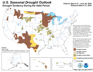
Some drier areas that received below normal precipitation are portions of central Idaho, the Arizona Strip, and portions of eastern Utah. The Great Basin is generally absent of drought, except for far southern Nevada, the Arizona Strip, and far eastern Utah where abnormally dry conditions still exist. These areas will likely see some improvements to the drought into the spring as El Niño potentially brings more precipitation to the south.
There is an 83% probability that ENSO Neutral conditions, neither El Nino nor La Nina, will return by the April-May-June 2024 timeframe. However, El Nino is expected to continue impacting weather patterns in the U.S. into the spring. A La Nina Watch issued by the Climate Prediction Center remains in effect — meaning La Nina conditions could return to the equatorial Pacific within six months.
According to climatologists, that transition, in addition to the record-warm water temperatures in the Atlantic Ocean, could mean we could be facing an active 2024 Atlantic hurricane season.
NOAA’s spring perception outlook favors below-average rain and snow for parts of the Northwest and northern Rockies, as well as in the Rio Grande Valley in the Southwest.
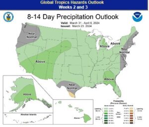
However, the forecast for Arizona seems to be above average for March 31 to April 6.
“Our scientists at the Climate Prediction Center observed one of the strongest El Nino events on record during the winter of 2023-2024,” said Jon Gottschalck, chief of the Operational Prediction Branch from NOAA’s Climate Prediction Center. “But a quick transition to La Nina — the cool phase of ENSO — is possible as early as the first part of summer.”
Below normal precipitation will continue across portions of the Northwest through late spring, with below normal precipitation likely to encompass much of Texas, New Mexico, and eastern Arizona.
According to the National Weather Climate Prediction Center at the National Weather Service the seasonal precipitation outlook, April through June shows equal chances for precipitation.
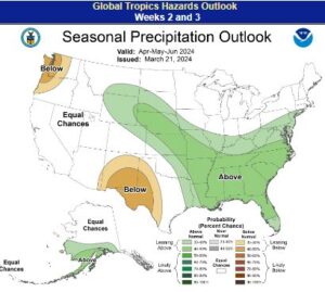
outlook. April-May-June.
Wildfire Outlook
Fuel moisture will continue to increase through the spring. The National Interagency Fire Center will continue to monitor the areas of eastern Utah, southern Idaho, and northern Nevada that have above normal fine fuel loading for windy conditions after prolonged dry periods that may increase fire potential for a burning period or two, as grasses will be dormant through at least early spring.
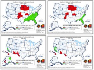
While normal significant fire potential is expected for much of the region from March to June, some areas of above normal significant fire potential are expected across both the southeast and eastern sections of the region during the spring. In addition, areas of above normal significant fire potential are likely to arise across portions along and south of the Mogollon Rim later in May into June.
Over the bulk of the period from late last fall through January, precipitation was below normal across central and western Arizona and across far southeastern New Mexico, while southern sections of Arizona and much of central New Mexico experienced above normal precipitation. During February, some wetter than normal areas occurred across northern into northeastern New Mexico and across southern Arizona into southwestern New Mexico, while western into central Arizona was below normal and southeastern New Mexico saw below normal precipitation.
Governor Katie Hobbs said Monday that the time for action is now. “Residents and visitors need to do their part to prevent wildfires,” she said in Monday’s briefing.
Sections along and south of the Mogollon Rim could point towards above normal significant fire potential later in the spring into the early summer given elevated amounts of fine fuels according to the National Interagency Fire Center.
This year, and due to heavy fuel loading, fire behavior analysts at Arizona Department of Fire Management report the potential for higher-than-normal activity in particular parts of Arizona. Areas south of the Mogollon Rim, within the Tonto National Forest and across the Sonoran Desert landscapes, down into the Catalinas, and into Cochise County may see increased fire activity due to the amount of grass and brush in those areas. The potential exists for quick ignitions and rapid moving wildfire within the areas of heavy fine fuel where winds and terrain can influence fire behavior making it challenging for firefighters to contain.
“Those parts of the state have more than double the amount of fuel loading as in years past due to winter rains over the last few years. As we move into spring, and as drier and warmer conditions follow, that fuel dries out very quickly. Areas within the Sonoran Desert and into southern Arizona could see an uptick in fire activity with fires spreading very rapidly,” said DFFM Fire Management Officer John Truett.
As for the high country, fire behavior analysts report a delayed start to fire season due to the existing snowpack. However, unlike last year, that snowpack may melt sooner as warm temperatures enter the state. Forecasters say by May Arizona could see the start of our typical summer pattern of hot and dry conditions. Those conditions can signal the start of Arizona’s fire season.
In 2023, firefighters responded to 1,837 fires on State, Federal, and Tribal lands. Those fires burned approximately 188,000 acres with 71% reported as human-caused. Last year, Arizona’s largest fire, the Pilot Fire started on July 1, east of Wikieup, within the Mohon Mountains. It reached 34,810 acres before firefighters could call it 100% contained on August 12, more than one month after it started.
March 25, Southwest Wildfire Awareness Week kicks off in Arizona and New Mexico with this year’s theme: A Time for Action. The week helps amplify wildfire prevention and outreach messaging prior to the states’ critical fire timeframes. To promote the week, DFFM and partners will focus on increased social media messaging, public service announcements, and public outreach events.
“A Time for Action” signifies getting homeowners to start creating defensible space around homes and around properties. DFFM and its federal and tribal partners work annually conducing fuels reduction and prescribed burn projects to reduce the wildfire risk around communities. Home repair, seasonal cleanup, taking care of plants, and removing trash and debris from around the home are just a few ways to prepare your home for wildfire.
This year, DFFM also unveils a new marketing campaign at gas stations aimed at reducing roadside fires and other prevention information.
Finally, May and June are forecast to see above normal significant fire potential in the Texas mountains due to worsening drought and areas of normal fuel loading. If the North American monsoon is delayed at all, the risk for lightning-caused fires may be pushed back later into the summer.
